EUSI Monitors Baltics-Russian Border Amid Dangerous Conditions for Aerial Remote Sensing and GEOINT Data Collection

European Space Imaging (EUSI) is working closely with European intelligence agencies and key NATO MoDs to continuously monitor the volatile border along Estonia, Finland and Latvia. Between widespread GPS jamming, increased Russian air activity and military postering along these border regions, it has become unsafe for many commercial and government aircraft to collect vital data for both security and civil mapping projects.

GPS Jamming

Russian forces have been increasingly jamming GPS signals throughout the regions between St. Petersburg, the Baltic nations and Scandinavia since February 2022. This made headlines earlier this year as commercial passenger flights were forced to turn around and aviation officials raising safety concerns.

GIF: GPS jamming by Russia

Animation depicting GPS Jamming activity around the Baltics and Finland. Source: GPSJAM

Likened by some officials to “driving without headlights”, flying in areas with heavy GPS jamming incidents is not only risky for passenger airlines but also for other civil aircraft collecting important remote sensing data for land use mapping, agriculture and emergency response. Tapio Pyysalo, head of international relations at Europe’s Centre of Excellence for Countering Hybrid Threats, commented on the seriousness of the situation: “The danger to civil aviation is real and serious.”

With some aerial data suppliers unable to safely plan and execute their collection plans, it has left a serious gap in the data and a need to fill with comparable imagery sources.

Risk to Aircraft from Russian Forces

While GPS jamming can severely disrupt civil aircraft operations, military aircraft are able to navigate conflict zones using other methods. This does not, however, mean that Estonian, Latvian, Lithuanian and Finnish forces can fly intelligence collecting missions without increased risk. These border regions have seen increased military activity from both sides since the start of the War in Ukraine. A significant build-up of Russian military equipment and personnel at the border along with provocations means that every military flight near the border for any reason carries a high risk factor.

Satellite Imagery as a Low-Risk Solution

Neither GPS jamming nor conflict tensions affect remote sensing satellites’ ability to collect critical data. EUSI directly downlinks to the Maxar Constellation to deliver 30 cm GSD optical satellite imagery from its ground station at the German Aerospace Center (DLR) near Munich, Germany. From this location, the operations team employs Intelligent Collection Planning (ICP) procedures and Near Real-Time delivery as fast as 15 minutes to constantly monitor key areas around Europe that are crucial to the region’s safety and security.

Both satellite and aerial imagery play important roles in remote sensing initiatives around Europe and both data collection methods have their strengths and weaknesses in certain scenarios. The persistent monitoring by EUSI of these border regions provides much-needed data to local authorities as well as research and cadastral projects in the Baltics that have been disrupted by the ongoing conflict.

Share on facebook
Share on twitter
Share on linkedin

Related Stories

MGP Pro Demonstration

Instant access to VHR satellite imagery via web or API. European Space Imaging recently recorded a webinar in which they demonstrated all the functionality of

Read More »
Worldview Legion launch dispensor on SpaceX rocket

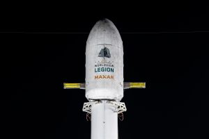
EUSI Will Soon Offer Intraday Monitoring Across Europe After Maxar’s Second Successful Launch of WorldView Legion Satellites

With the successful launch of Maxar Intelligence’s second set of WorldView Legion satellites, European Space Imaging (EUSI) will soon offer up to eight daily collection opportunities in key latitudes across Europe and North Africa – a number that will increase after the final WorldView Legion satellites are launched and all six satellites are operational.

Read More »
Satellite image of the Olympic Stadium in Munich

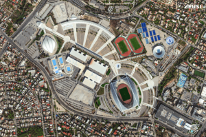
A Bird’s-Eye View: Olympic Stadiums of Europe from Space

The whole world is watching the Olympic Games in Paris with bated breath. But it’s not the first time the Summer Olympics have been held in Europe – 14 stadiums have been built across 10 countries, each of them unique and capturing the spirit of the cities that hosted them. Which one is your favourite?

Read More »