Satellite Imagery for Emergency Management
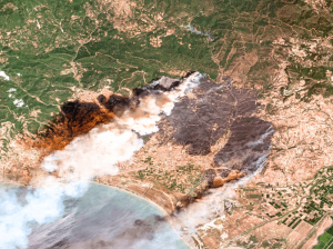
The use of satellite imagery for emergency response and management is invaluable. Both optical and SAR images help rescuers save lives when disasters happen, assist with damage assessments, and in many cases contribute to successfully preventing and predicting emergencies. Which events can be prevented? How exactly do first responders use satellite images? When are they better than other methods? We have summarised our 20+ years of experience in this article.
Satellite Imagery as a Valuable Tool for the New Common Agricultural Policy 2023–2027
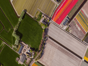
On 1 January 2023, the new Common Agricultural Policy for years 2023–2027 entered into force. Hand in hand with the provided subsidies goes the necessity for monitoring and controls, which falls to the individual Member States. Therefore, an efficient, reliable, and cost-effective source of data is needed. Such source is Very High Resolution (VHR) satellite imagery. It allows you to conduct in-depth analysis of plant and soil conditions, map land use at wide scales with incredible detail and accuracy, and ensure that agricultural goals are being met.
What is SAR Imagery? Introduction to Synthetic Aperture Radar
SAR imagery enables all-weather monitoring, penetrates dry soil, and offers resolution as high as 25 cm. Thanks to that, it’s invaluable for applications like emergency response, defence and intelligence, or agriculture. How does SAR work? What are its advantages and limitations? And what other data sources can you integrate it with? Read the article to learn more.
Discover
What's
NEW
FIND WHAT YOU'RE LOOKING FOR
Resource Type
Industry
Application
European Space Imaging and TotalView Provide Satellite Imagery for Greek LPIS 2014 Project
European Space Imaging and TotalView successfully completed the provision of DigitalGlobe’s (DG) satellite imagery products for the Land Parcel Identification System (LPIS) 2014 project in Greece. The project “Digital Services in the Single Application Renewed Land Parcel Identification System” project was announced by the Greek Payment and Control Agency for
European Space Imaging Announces New Partnership With Vricon
European Space Imaging, Europe’s leading very high-resolution satellite imagery provider, has entered into an agreement with Vricon, the leader in high-accuracy 3D data and digital elevation models with global coverage. This partnership gives European customers easy access to The Globe in 3D and will be of particular benefit to government
European Space Imaging Appoints New Sales Director
European Space Imaging is pleased to announce the appointment of new Sales Director, Pascal Schichor, starting beginning of July 2018. Pascal has a long standing history with European Space Imaging after first joining the company in 2006 and holding a range of job roles before departing from his role as
European Space Imaging Awarded €20.5 million Agriculture Framework Contract by European Commission
Leveraging their high success rate from previous years, European Space Imaging has been awarded a fourth multi-year agriculture framework contract to deliver an estimated 1.2 million square kilometres of Very High Resolution (VHR) satellite imagery and associated services in support of the European Commission’s (EC) Common Agricultural Policy (CAP). This
European Space Imaging Awarded Major European Commission Contract for CAP
European Space Imaging announced today that they have joined forces with e GEOS and DigitalGlobe to provide imagery and data processing services as part of the multi-year framework supply contract with the European Commission for the provision of very high-resolution satellite data and associated services in support of the European