
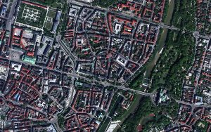
Maritime Domain Awareness in European Arctic Regions With VHR Satellite Intelligence
With the Arctic warming nearly four times faster than the average, the ice in the High North is melting and the sea is becoming increasingly navigable. In 2025 alone, 1812 vessels entered the Arctic Polar Code area, which is a 40% increase since 2013 when data collection began. While this rise in traffic presents potential commercial opportunities, more vessels also mean more risks to people and resources.
European Space Imaging Renews Contract With Maxar Technologies To Provide Europe With The World’s Best Resolution Commercial Satellite Imagery
European Space Imaging and Space Imaging Middle East have extended their ongoing contract with Maxar Technologies, provider of comprehensive space solutions and secure, precise, geospatial
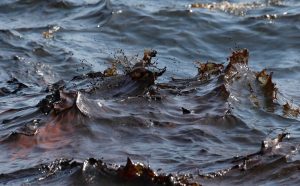
Increasing Situational Awareness of Conflict Linked Oil Pollution with VHR Satellite Imagery
Very High Resolution (VHR) satellite imagery is often used as a source of truth to verify what is happening on the ground in hard to

Combing VHR Satellite Imagery and Deep Learning to Detect Landfills
Satellite imagery and remote sensing has been used extensively for monitoring land usage and land cover. With increasing availability of Very High Resolution (VHR) satellite
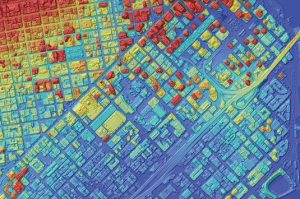
Expanding Product Offering: AW3D
European Space Imaging is expanding our elevation product offering with the addition of AW3D, a highly accurate set of Digital Elevation Models with global coverage.
Mapping Methane with VHR SWIR Imagery
Methane is the second most important greenhouse gas and its concentration in the atmosphere is currently increasing at a rate of around 1% per year.
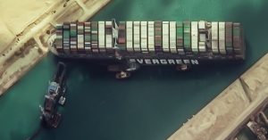
SUEZ CANAL, EGYPT: Satellite Images Show Stuck Container Ship
At 400 m long and 59 m wide, a 200,000 tonne container ship has been blocking the passage of other vessels in both directions along
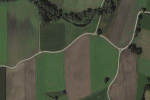
European Space Imaging Awarded €20.5 million Agriculture Framework Contract by European Commission
Leveraging their high success rate from previous years, European Space Imaging has been awarded a fourth multi-year agriculture framework contract to deliver an estimated 1.2

Heeding the Herd: Detecting Elephants from Above
VHR satellite imagery supplied by European Space Imaging to Isla Duporge, Lead Project Researcher from WildCRU at University of Oxford, has been combined with machine
Satellogic successfully launches 10 new satellites expanding European Space Imaging’s satellite access portfolio
On Friday 6 November, Satellogic, the first company to develop a scalable Earth observation platform with the ability to remap the entire planet at both
Another year delivering 100% success rate to the European Commission’s CwRS Programme for European Space Imaging
Despite the challenges incurred from COVID-19 in 2020, European Space Imaging has once again finalised the collection of Very High Resolution (VHR) satellite imagery for
Partnership with Satellogic: Increases Capacity for Key European Remote Sensing Projects
European Space Imaging has signed a partnership agreement with Satellogic, an innovative player in the satellite imagery and geospatial analytics industry. The first to sign
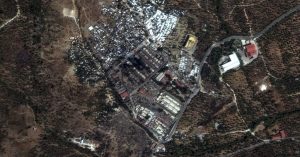
Moria, Greece: Satellite Images Show Fire Damage
Nearly 13,000 people are left without shelter after the fires have burnt down most of the Moria Camp on the island of Lesbos, Greece. Very


