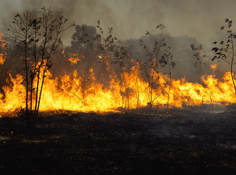
VHR Satellite Images for Wildfire Monitoring
High temperatures are breaking records, vegetation is drying up, and catastrophic wildfires are raging across Europe. Emergency responders are already turning to satellite imagery for fire monitoring and damage analysis – but few know its full potential. Near Real-Time (NRT) capabilities deliver critical images just 15 minutes after collection. Intraday imaging captures a fire as it develops throughout the day. And 8-band multispectral imagery lets responders see through haze, light fog, and other atmospheric conditions – including wildfire smoke itself.
Partnership with Satellogic: Increases Capacity for Key European Remote Sensing Projects
European Space Imaging has signed a partnership agreement with Satellogic, an innovative player in the satellite imagery and geospatial analytics industry. The first to sign
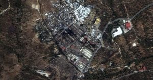
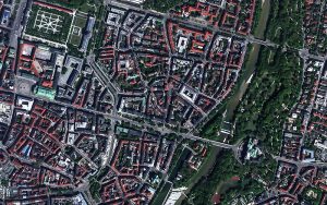
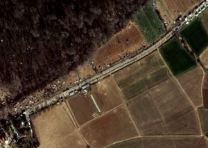
Moria, Greece: Satellite Images Show Fire Damage
Nearly 13,000 people are left without shelter after the fires have burnt down most of the Moria Camp on the island of Lesbos, Greece. Very
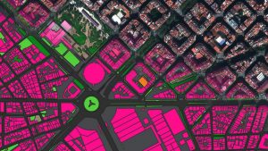
Ecopia Global Feature Extraction (GFX) Powered by European Space Imaging
European Space Imaging has recently signed a contract with Ecopia.AI, a trusted partner and global innovator in HD Vector Maps harnessing artificial intelligence and innovative
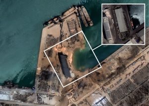
BEIRUT, LEBANON: Satellite Images Show Explosion Damage
At least 100 people have died and 4,000 people have been wounded in a massive explosion in Beirut, Lebanon on Tuesday 4th August 2020. Very

How Oil Pollution Impacts the Health and Livelihoods in Conflict-affected Northeast Syria
PAX and its local partner PEL – Civil Waves have investigated the years-long impact of oil pollution in northeast Syria using Very High Resolution (VHR)
The Libyan Conflict through the Lens of Very High Resolution Satellite Imagery
Very High Resolution Satellite Imagery at True 30 cm can provide crucial insights for geointelligence (GEOINT) during conflict. It can act as a source of

Pascal Schichor Successfully Elected to the EARSC Board of Directors
European Space Imaging are proud to announce that Pascal Schichor, Sales Director, has been successful in his election to the European Association of Remote Sensing
30 cm Satellite Imagery as an Alternative to Aerial Data
Remote sensing projects can often begin with the question “Should I use aerial imagery or satellite imagery?”. This question may come up again and again

EU Commission Asks EO Community for Help With COVID-19
On Friday, 27 March, DG DEFIS (European Commission Department for Defense Industry and Space) issued an urgent request for Earth Observation resources that could provide

To See the Sea – Achieving Total Maritime Awareness With VHR Satellite Imagery
The ocean is a precious resource that all Europeans make use of in one way or another. Over 200 million of us live near the
TURKEY-GREECE BORDER: Satellite Images Show Refugee Crisis
Thousands of refugees wait patiently in line at the Turkey border, as they await passage into Greece. Satellite images captured early on 3 March, 2020
SpaceWatch Global Interviews Adrian Zevenbergen
SpaceWatch.Global’s Torsten Kriening had the chance to speak with Managing Director Adrian Zevenbergen at SpaceTechExpo Europe in Bremen about the company’s business, the earth observation


