
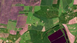
Earth Observation Turns Ecological Targets into Measurable Outcomes: How Satellite Imagery Supports Compliance with Europe’s Nature Restoration Regulation
The EU’s Nature Restoration Regulation (NRR) entered into force in 2024 and set legally binding targets to restore degraded ecosystems across Europe. With National Restoration Plans due in September 2026, Member States face an urgent question: how do you map, plan and monitor restoration across millions of hectares in a consistent, verifiable way? Earth Observation (EO) – and Very High Resolution (VHR) multispectral satellite imagery in particular – is increasingly the answer.

Satellite Imagery for Railway Vegetation Management
True 30 cm Very High Resolution (VHR) satellite imagery is being adopted for railroad companies across Europe in an effort to develop remote sensing methods
European Space Imaging Delivers 100% Success Rate of European Commission’s CwRS Program
Early last week European Space Imaging finalised the collection of close to 400,000 square kilometers of Very High Resolution (VHR) satellite imagery for the European
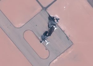
Press Release: Jufra District, Libya – GNA Destroys LNA Supply Aircraft
JUFRA DISTRICT, LIBYA: GNA Destroys LNA Supply Aircraft European Space Imaging has collected satellite images on July 29 depicting two destroyed aircraft at Al-Jufra Airbase.
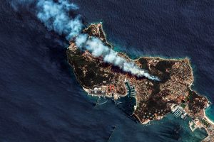
Press Update: Southern France – Satellite Images of Pine Forest Fire in the Var
European Space Imaging collected an image with WorldView-2 near Saint-Mandrier-sur-Mer in the Var yesterday afternoon as a pine forest fire fuelled by a Mistral wind
Portugal Wildfires: Rapid Delivery of Satellite Imagery in Emergency Situations
European Space Imaging accepted overnight orders to deliver Very High Resolution satellite imagery for the Copernicus Emergency Management Service (EMS) in response to devastating wildfires

PRESS UPDATE: European Space Imaging signs contract with Maxar to sell SecureWatch and EarthWatch
European Space Imaging today signed a contract with Maxar Technologies, a trusted partner and global innovator in Earth intelligence and space infrastructure, to offer SecureWatch

Arrival Cities: Classifying Urban Poor Areas with Satellite Imagery
Hannes Taubenböck and his team at DLR are using Very High Resolution (VHR) satellite imagery, supplied by European Space Imaging, combined with auxiliary surveys to
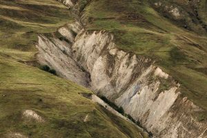
Mapping Landslides with VHR Satellite Imagery
Copernicus Emergency Management Service is using Very High Resolution (VHR) satellite imagery supplied by European Space Imaging to create grading maps and analyse damage after

VHR Remote Sensing for Impervious Surface Estimation
Tobias Leichtle from DLR investigates how WorldView-2 very high resolution satellite imagery sourced from European Space Imaging can be used for impervious surface estimation. Urbanization

Europe’s SAR and Optical Satellite Integration
Europe’s all-inclusive integrated solution to leverage the power of SAR and VHR optical satellite imagery European Space Imaging is the only European supplier that is
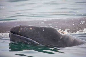
Satellite Imagery shows whales held captive in Russia
Satellite images show whales being held captive in Russia’s Srednyaya Bay amongst international outcries for the animals’ release. Reports say that up to 100 whales

Penguins From Space: VHR Satellite Imagery to Decrease Vulnerability
Researchers from the British Antarctic Survey embarked on a world first journey to find emperor penguins from space using very high resolution optical satellite imagery.


